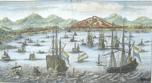
Malaysia, Malakka (Melaka Bandaraya Bersejarah) De Renneville, 1703, Malaca
Very uncommon map with a striking wide panoramic view of the city of Malacca (Malakka or Melaka Bandaraya Bersejarah) with many Dutch and local ships on the foreground. It is a vivid and finely detailed 17th-century Dutch view of Malacca, based on drawings by VOC ship’s surgeon Wouter Schouten, whose travels through the East Indies from 1658 to 1665 formed the basis of one of the most richly illustrated Dutch travel accounts of the era.
At the time of Schouten’s visit, Malacca had become a linchpin in the Dutch East India Company’s campaign to dominate the spice trade and displace Portuguese and Muslim commercial rivals. This engraving shows Malacca from the sea, its harbor teeming with merchant ships, Chinese junks, and native craft. On the hill overlooking the city rise the massive Portuguese fortress A Famosa and the church of St. Paul, both taken over by the Dutch after their conquest of Malacca in 1641. The view highlights the strategic and commercial centrality of the city, which served as a critical VOC outpost controlling the narrow straits between the Indian Ocean and South China Sea.
Published in Constantin Renneville's ´Recueil des voyages qui ont servi a l'etablissement et aux progres de la Compagnie des Indes Orientales, ... tome 3´, first published in 1703.
Very good condition. Folds as published. Very clear print.
Image 13,5x25,5cm, page 16x27,5cm


