Information
Welcome to the Mapminded blog! Here, we share interesting stories about cartography, historical maps and engravings, and the fascinating people who created them. Join us on a journey through history and artistry.
Mapping the Unknown: A Glimpse into 16th and 17th Century Cartography
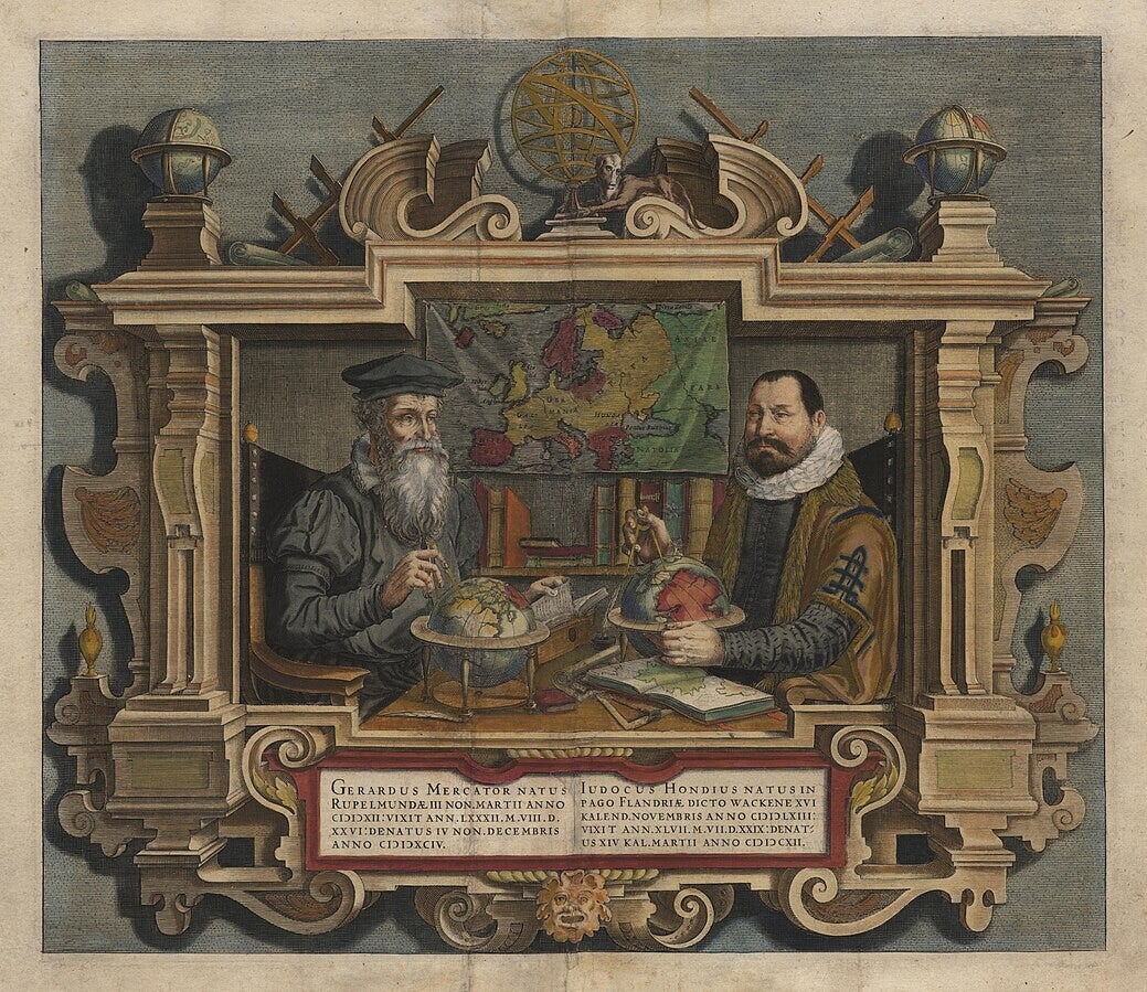
The allure of the unknown has always captivated humanity, and in the 16th and 17th centuries, this fascination was expressed clearly in cartography. Important mapmakers like Abraham Ortelius, Gerard Mercator, and Jodocus Hondius embarked on ambitious projects to chart a world still largely unknown in detail, with some areas still being completely uncharted.
Imagine a time when vast continents were mere outlines, and entire oceans were dotted with speculative islands and mythical beasts. This was the landscape these early cartographers faced. Their work wasn't simply about documenting existing knowledge; it was about synthesizing fragmented reports from explorers, sailors, and merchants, and then filling in the immense blanks with a blend of educated guesses and sheer imagination.
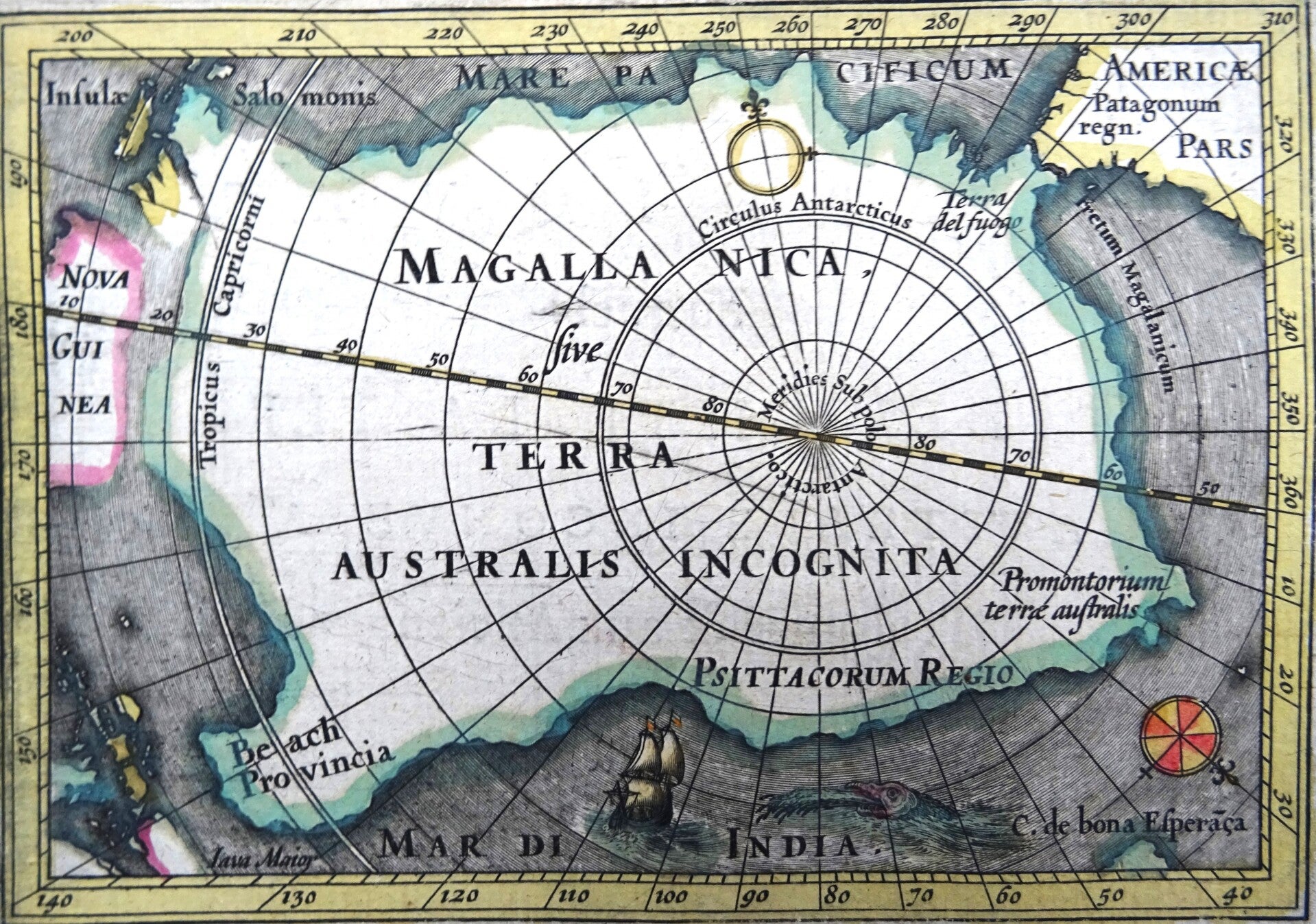
Ortelius's "Theatrum Orbis Terrarum," published in 1570, is often considered the first true modern atlas. It was a monumental achievement, bringing together maps from various sources into a coherent collection. Yet, even within its pages, one can see the struggle to depict accuracy. His maps of the Arctic, for instance, often depicted a central magnetic pole surrounded by four landmasses, a concept derived from earlier, less accurate theories. Similarly, "Terra Australis Incognita" – the unknown southern land – was a recurring feature, its size and shape shifting with each new conjecture.
Mercator, renowned for his projection that revolutionized navigation, also grappled with the limits of available information. While his projections offered a practical solution for sailors, the actual landmasses he depicted were often speculative. His map of the world, like many of his contemporaries, included fanciful details in the vast, unexplored regions, a testament to the blend of scientific pursuit and artistic license.
Jodocus Hondius, who later acquired Mercator's plates, continued this tradition. His editions often incorporated new discoveries, yet the fundamental challenges remained. Consider the intricate details often found along the edges of these maps – mythical creatures, indigenous peoples depicted through a European lens, and elaborate cartouches. These weren't just decorative elements; they served to engage the viewer, adding narrative and wonder to areas where factual geographic data was scarce.
These maps, far from being perfect representations, offer a fascinating window into a world on the cusp of discovery. They reflect the human desire to impose order on chaos, to visualize the unseen, and to push the boundaries of knowledge. The "unknown" was not a barrier but a canvas for these cartographic pioneers, whose legacy continues to inspire awe and curiosity about how we came to understand the true shape of our planet.
The Hondius Family: Masters of 17th-Century Cartography
The 17th century was a golden age for cartography, and among the most influential figures of this period were members of the Hondius family. Originally from Ghent, the family moved to Amsterdam, which was rapidly becoming the center of mapmaking in Europe. Their work combined artistry, technical precision, and commercial vision, shaping how the world was seen and understood in an age of exploration.
The patriarch, Jodocus Hondius (1563–1612), is often credited with reviving the great atlas tradition. When Gerardus Mercator’s monumental Atlas struggled to find commercial success, Hondius acquired the plates and published a new, expanded edition in 1606. By adding his own maps and updating content with fresh geographic knowledge, he transformed Mercator’s atlas into a bestseller. This ensured Mercator’s projection and vision lived on, while also cementing Hondius’s reputation as one of the foremost cartographers of his time.
Hondius was not just a skilled geographer but also an engraver of remarkable talent. His maps stood out for their elegant ornamentation—ships sailing on vast seas, elaborate compass roses, and vivid depictions of animals and peoples in distant lands. These features made his maps not only practical tools but also works of art, coveted by scholars, merchants, and collectors alike.
After his death, the business passed to his sons Henricus (1597–1651) and Jodocus II (1594–1629), who continued expanding the family’s publishing empire. They issued further editions of the Atlas, often collaborating with other major figures such as Jan Janssonius. These collaborations blurred the lines between rival publishing houses, but also drove innovation and competition that enriched 17th-century cartography.
The Hondius family’s impact went beyond publishing atlases. They played a key role in the dissemination of geographic knowledge during an era when European nations were fiercely competing for global dominance. By making maps more accessible and visually compelling, they influenced not only navigation and trade but also the European imagination of the wider world.
Today, maps by the Hondius family are prized in collections and museums, valued as much for their historical significance as for their artistry. They remind us that maps are more than geographic records—they are cultural artifacts that reflect the ambitions, anxieties, and worldviews of their time.
The Hondius family’s legacy lies in their ability to merge science and art, commerce and knowledge. Their work helped define the cartographic standards of the 17th century and ensured that the age of exploration would be visually preserved for generations to come.

An Early Map of Sumatra
One of the earliest, desirable maps of the island of Sumatra and the southern part of Malaysia is titled´Sumatra ein Grosse Insel so von den alten Geographen Taprobana genennet worden.´.
This map is SebastianMünster´s revision of the early Ptolemaic map of the same name, which confused Sumatra with the island of Ceylon. It is one of the earliest maps to focus on this region. Shown nearby is today's Singapore, on the tip of the Malay peninsula, and named ´Cingafufa´.
The text to the right quotes Pliny, and below that is a large engraving of an elephant and his mounted handler (oddly dressed in European clothes).
Sebastian Munster (1489 - 1552) was one of the three most renowned cartographers of the sixteenth century, along with Mercator and Ortelius. Munster's Geographia and Cosmographia Universalis were two of the most widely read and influential books of the period. His editions of Ptolemy's Geographia, published between 1540 and 1552, were illustrated with 48 woodcut maps, the standard 27 Ptolemaic maps supplemented by 21 new maps. These new maps included a separate map of each of the known continents and marked the development of regional cartography in Central Europe. The antique geography was a prelude to Munster's major work, the Cosmographia, which was published in nearly 30 editions in six languages between 1544 and 1578 and then was revised and reissued by Sebastian Petri from 1588 to 1628. The Cosmographia was a geographical as well as historical and ethnographic description of the world. It contained the maps from the Geographia plus additional regional maps and city views with nearly 500 illustrations which made it one of the most popular pictorial encyclopedias of the sixteen century.
Find Your Own Antique Map
Discover the perfect genuine antique map or engraving to enrich your collection or add a touch of historical elegance to your home. At Mapminded, based in Spain and active since 2016, we offer a beautiful selection of unique pieces that tell stories of the past. Explore our collection and find a map that speaks to you!